
Planning an Ottawa Itinerary Without a Car
Yes. An Ottawa sightseeing itinerary without a car is practical when the day is centred on compact, well-connected areas: walk between genuinely nearby stops and use public transit for longer gaps. Keep outlying attractions only when their round-trip travel, transfers, walking and return timing fit the day without displacing the main route.
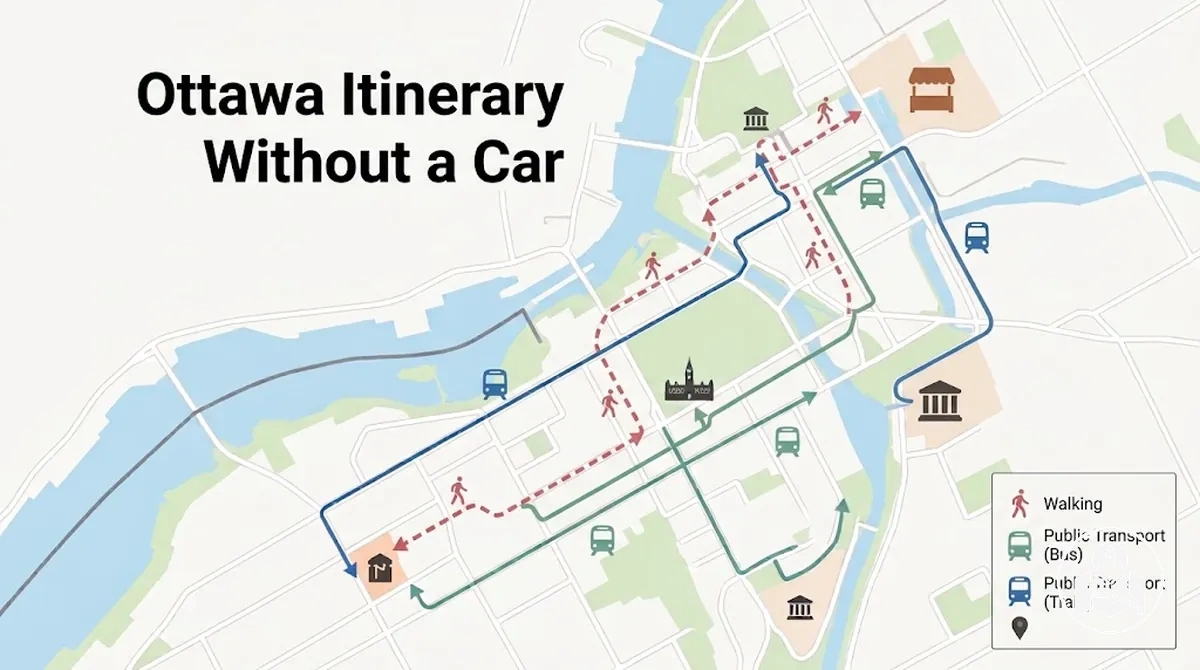
Car-free Ottawa day planner
Build the itinerary in four linked decisions so route compactness, transport, timing and fallback choices stay connected.
-
Cluster the stopsGroup nearby attractions first and use a convenient base that reduces repeated cross-city travel.
-
Choose the movement modeWalk for practical nearby connections; use public transit when a longer gap would consume disproportionate time or effort on foot.
-
Budget the whole movement legAdd walking, waiting, transit, transfers and a contingency buffer, then check the result against attraction opening hours.
-
Protect the main routeIf one leg breaks the schedule, reorder nearby stops, reschedule or omit a time-heavy outlying stop, or substitute a closer stop.
- Strong car-free fit
- Compact attraction clusters, manageable walking and workable transit connections.
- Outlying-stop test
- Judge the complete outward and return access burden, not geographic distance alone.
- Day-capacity rule
- As movement and uncertainty time increase, the practical number of sightseeing stops decreases.
Table of Contents
Can You Sightsee in Ottawa Without a Car?
Yes, central Ottawa sightseeing can generally be planned without a car when the attractions you want to visit are concentrated in walkable areas or are transit-accessible.
Stronger fit
- Attractions are concentrated in walkable areas or form compact sightseeing clusters.
- A central base keeps more planned stops within practical walking range.
- The pedestrian route suits the traveller's mobility and walking tolerance.
- Public transit provides a workable connection for the longer gaps between areas.
Reassess the route
- An outlying stop adds substantial outward and return travel.
- Several transfers are required or the connections are poorly aligned.
- The walking burden exceeds what the traveller can comfortably manage.
- Service at the required time does not support a workable outbound or return connection.
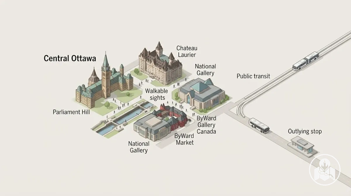
Within the broader set of Ottawa travel itineraries, the useful rule is to treat central, well-connected attractions as the stronger fit for a no-car trip and evaluate outlying stops separately before adding them.
Plan the Route Around Walkable Sightseeing Areas
Build compact route clusters around walkable sightseeing areas before deciding how to move between them.
This order keeps nearby attractions together first, then treats each longer connection as a separate movement constraint in the route sequence.
First assess whether the desired stops in each sightseeing area form a compact cluster with workable walking continuity; then assess the connection cost in travel time and effort, including whether public transit is needed to reach the next area.
Base access also matters, so travellers can stay in a convenient sightseeing area when that location reduces repeated travel to the first or main route cluster.
The diagram shows how proximity within clusters and longer connections between them shape route order.
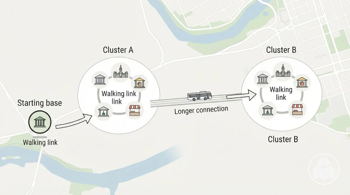 Turning those spatial relationships into an executable route requires a fixed sequence of planning decisions.
- Select the sightseeing stops you want to include.
- Group nearby attractions into compact route clusters.
- Check how easily the base location connects to the first and main clusters.
- Evaluate the connection between each cluster and the next one without driving.
- Time-check the complete route sequence so longer connections do not consume an unreasonable share of the sightseeing period.
For example, a centrally located base may let a traveller begin near one cluster, continue through nearby attractions on foot, and make only one longer connection to another sightseeing area instead of repeatedly crossing the city.
The useful planning test is whether the base location and cluster sequence reduce unnecessary movement while keeping the planned travel time compatible with the day.
Keep Nearby Attractions in the Same Route Segment
Nearby attractions fit the same route segment when proximity, walking continuity, and opening-time compatibility allow them to be visited in sequence without a long detour.
Grouping those stops together reduces unnecessary transfers and limits backtracking, while a timing conflict or broken walking connection can make a nearby stop a poor fit for that segment.
A compact cluster keeps sightseeing stops on a continuous route, whereas scattered stops create longer detours and repeated movement.
The image contrasts a compact segment with a distant stop that would require extra backtracking.
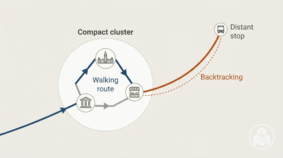 When the local grouping becomes more complex, it is more useful to group attractions by nearby areas before deciding the final route sequence.
Keeping only compatible nearby stops in the same segment preserves more of the available time for sightseeing instead of repeated transfers or retracing the route.
Decide Which Outlying Stops Are Practical Without Driving
An outlying attraction is practical without driving only when its total access cost fits the available day, including the journey out and a realistic return option.
Itinerary fit therefore depends on more than geographic distance: total travel time, transfers, walking distance, service frequency, and operating hours can all change whether the stop works.
Assess access burden first, then check whether the available connections fit the attraction's operating hours and your planned return.
The graphic organises the walking segments, transfer points, and return connection that can make an apparently reachable stop more complicated in practice.
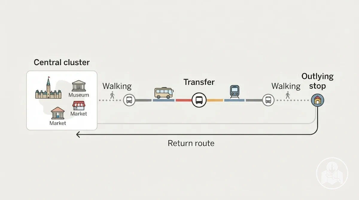 For example, a hypothetical outlying stop that appears relatively close may still be a time-heavy fit when it requires several transfers and substantial walking at both ends, while a farther stop with a simpler connection may fit the day more easily; distance alone does not determine practicality.
- Total travel time: include the complete outward and return journey; a large share of the available day makes the stop a time-heavy itinerary fit.
- Transfers: each required transfer adds connection complexity and can make the outlying stop less practical when connections are poorly aligned.
- Walking distance: consider walking at both the arrival and departure ends; longer or unsuitable walking requirements can increase the access burden for the traveller.
- Service frequency: less frequent service can increase waiting risk and reduce flexibility, while more usable service intervals can make the connection easier to fit into the itinerary.
- Operating hours: the outward journey must leave enough usable time at the attraction before it closes or otherwise becomes unavailable.
- Return option: a practical plan requires a realistic return connection under the expected service conditions; without one, the stop may not fit the available day.
Follow Each Route Segment on Foot and by Public Transit
For each route segment, use walking when the next stop is genuinely nearby and the path is practical on foot, and consider public transit when the gap would consume disproportionate time or walking effort.
Check the movement leg before leaving because distance, expected duration, transfer requirements, and current service availability can change which option fits the day's route.
Follow the same sequence for each movement leg so walking and public transit remain part of the sightseeing route rather than a separate transport plan.
The visual shows how one route segment can move from a nearby walking leg to a longer transit connection and then to the next stop.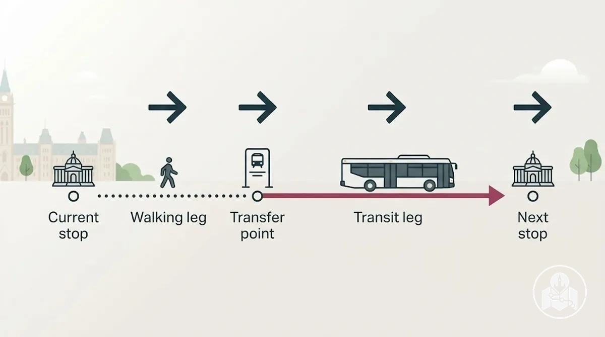
- Confirm the next stop: check that it is still the next planned destination before starting the route segment.
- Check the mode: compare the distance, expected duration, and walking effort; walk for a practical nearby connection or consider public transit for a longer inefficient gap.
- Allow for transfer time: if the leg uses public transit, account for boarding, any required transfer, and the service availability relevant to that trip before continuing.
- Travel the segment: follow the chosen walking or transit leg and confirm that it still connects appropriately to the next stop.
- Reassess before continuing: check the remaining time, walking effort, and current service conditions before adding or starting another movement leg.
Current service conditions should be verified when the itinerary is used rather than assumed to remain fixed.
If the expected duration, transfer requirement, service availability, or walking effort changes, reassess the next stop and mode before continuing so the route segment remains workable within the day.
Walk Between Nearby Sightseeing Stops
Walking is the simplest way to move between nearby stops when the pedestrian route is continuous and the walking time fits the day's schedule.
It can avoid the transfer overhead of waiting for transit between genuinely close stops, but it is not automatically the better choice when pedestrian access, walking effort, or timing makes the leg inefficient.
Before starting the walking leg, confirm the walking route, pedestrian access, and realistic walking time, then check that arrival still keeps the next stop within its planned timing.
The image shows how a continuous pedestrian path connects nearby sightseeing stops without adding a transit transfer.
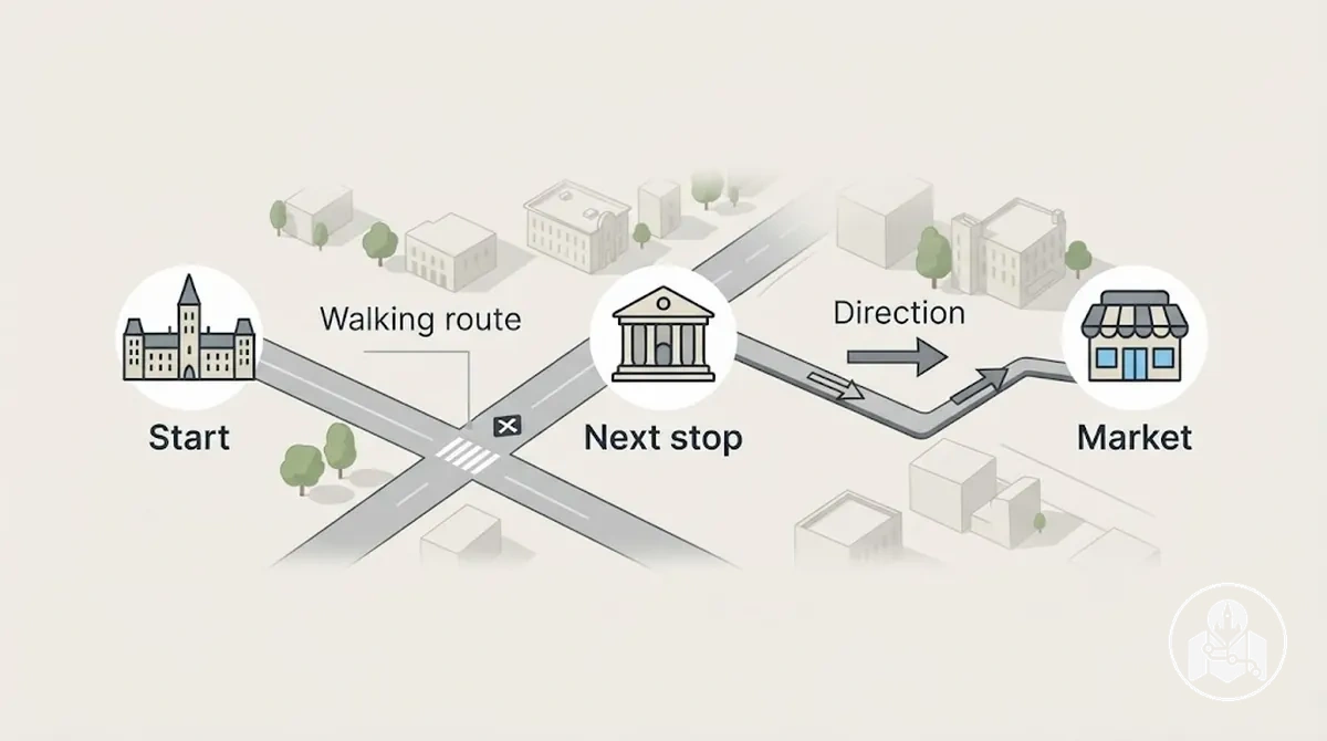 If the local leg is part of a longer pedestrian sequence, travellers can follow a self-guided walking route rather than extending this single segment into a separate citywide plan.
Walking becomes less efficient when greater distance, limited pedestrian access, accumulated fatigue, or delay undermines route continuity or the timing of the next stop.
Use Public Transit Between Distant Sightseeing Areas
Use public transit as the connector between distant areas when the next sightseeing area is inefficient to reach on foot.
Before committing to the transit leg, check the specific route, transfers, timing, and access because these checks reduce the risk of a longer connection disrupting the itinerary.
- Identify the route: confirm the connection to the next sightseeing area and check stop access, including the walking required at each end.
- Check the transfer requirement: determine whether the route is direct or requires a transfer, because additional transfers add coordination and can make the connection less reliable when service frequency is limited.
- Check timing and access: compare the expected travel window with service frequency and the walking needed to reach and leave the relevant stops, then verify that service is available for the intended trip.
- Confirm return feasibility: check that a workable return connection remains available for the planned time and day before committing to the outbound leg.
A transit connection with a simpler route and suitable service frequency may fit the itinerary more easily than one requiring several transfers or substantial walking at either end.
For broader transport use beyond this specific leg, travellers can use Ottawa public transport and walking while keeping this section focused on the longer connection between sightseeing areas.
Service patterns can vary by route, time, and day, so verify current trip details at the point of travel; if the transfer requirement, stop access, travel window, or return feasibility no longer fits the itinerary, reassess the leg before committing.
Set Realistic Timing for a Car-Free Sightseeing Day
A car-free sightseeing time budget must include movement and uncertainty time, not just the visit duration at each attraction.
Walking time, waiting time, transfers, and a contingency buffer all reduce the portion of the day available for sightseeing, so the feasible stop count depends on their cumulative effect.
Check the combined schedule against relevant opening hours. The allowance for each movement component varies with the route, traveller and service conditions, so use current trip details rather than a universal buffer.
Illustrative movement leg
- Walk
- 8 min
- Wait
- 7 min
- In transit
- 15 min
- Transfer
- 5 min
- Walk
- 10 min
- Total movement
- 45 min
This example uses 45 minutes before any attraction visit begins; it illustrates how small movement costs accumulate, not a standard travel allowance.
When several movement legs accumulate this way, reducing the planned stop count can make the timing plan more resilient than assuming attraction duration alone determines how much fits into the day.
Allow for Walking, Waiting and Transfers
Budget non-sightseeing movement time separately from attraction time before finalising the day's stop count.
Walking, waiting, transfers, and recovery time all consume the schedule, and their combined time can affect whether the next stop remains feasible.
Account for each movement-time component separately because several small time costs can accumulate across one connection.
How much each component adds depends on distance, walking pace, service conditions, and the connection required.
The combined time can delay arrival and reduce the schedule available for the next stop.
- Walking to the stop: allow for the distance and pedestrian access between the current sightseeing location and the departure point.
- Waiting: include the time before the relevant service arrives; the contribution can increase when the service interval or current conditions create a longer wait.
- Transfer time: account for any connection between services, including the time needed to reach the transfer point and wait for the next leg.
- Arrival walk: include the walking time from the arrival point to the next sightseeing stop rather than treating arrival by transit as the end of the movement leg.
- Recovery buffer: keep a small flexible allowance for plausible delay or additional walking effort so accumulated movement time is less likely to undermine the schedule.
Reduce Backtracking Before Adding More Stops
Reduce backtracking in an already workable route before adding more attractions.
Route optimisation means refining the stop order to reduce repeated movement; any usable time created by that simplification can disappear if another distant stop adds new cross-city travel or transfers.
Backtracking
Area A → Area B → Area A
The route repeats a cross-city leg and adds movement without adding a new sightseeing area.
Forward sequence
Area A stops → Area B stops
Complete the nearby Area A stops before continuing to Area B, keeping the same core stops with less repeated movement.
Keep area grouping intact while adjusting the sequence, and consider whether the start point and finish point support forward movement rather than unnecessary return travel.
This route simplification creates more usable time when it removes repeated movement without adding new complexity.
Judge the improvement by fewer unnecessary cross-city movements or transfers rather than by a claimed amount of time saved.
Adjust the Route When Car-Free Access Becomes Impractical
A car-free route becomes impractical when movement starts consuming too much time or effort for the day's main sightseeing objective to remain workable.
The troubleshooting task is to identify the observable disruption, check the likely access problem, and choose a corrective direction that restores route continuity without assuming the whole itinerary must be abandoned.
Signal → check → corrective direction
Slow or missed transit connection
- Check
- Next realistic departure and revised arrival time.
- Then
- Continue if the delay can be absorbed; otherwise simplify the downstream route.
Walking burden is greater than expected
- Check
- Walking effort, pedestrian access and the remaining time budget.
- Then
- Simplify the leg, change the sequence or substitute a closer stop when that preserves the main route.
Service gap at the required time
- Check
- Connection availability, transfer requirements and return feasibility.
- Then
- Use a different workable sequence or reschedule the affected stop rather than adding more transfers.
Outlying stop consumes too much of the day
- Check
- Round-trip travel, transfers, walking and opening-hour fit.
- Then
- Retain it only if the access burden fits; otherwise reschedule or omit the stop from this route.
Decision boundary: one disruption does not by itself make the whole car-free plan unworkable. Reassess the specific leg and revise the route only when the updated timing or access burden no longer fits the main sightseeing objective.
When a Transit Connection Is Slow, Missed or Unreliable
When a transit connection is delayed or a missed connection disrupts the planned sequence, check the next departure or a realistic alternate connection and recalculate the expected arrival time before continuing.
Compare that revised arrival time with the schedule for the downstream stop, including any relevant opening hours, so the effect of the delayed leg is clear rather than assumed.
An absorbable delay still leaves enough time for the downstream stop and the remaining route, while a route-changing disruption requires route simplification when the revised timing no longer fits.
For example, if the next realistic connection pushes arrival late enough that a low-priority stop would compress the rest of the day, route simplification may mean removing that stop while keeping the main sequence intact.
Do not treat one delayed leg as evidence that the whole transit system is unreliable; make the corrective decision from the specific connection and its schedule impact.
Continue with the original sequence when the delay can be absorbed, or revise the itinerary when the missed connection or delayed arrival makes the downstream stop impractical.
When an Attraction Requires Too Much Travel Time Without a Car
An attraction becomes a poor fit for the current car-free day when its round-trip travel time and access cost displace too much of the planned route.
The decision concerns itinerary fit rather than the quality of the attraction itself, so compare the time-heavy stop with the schedule it would replace before deciding whether to retain, reschedule, or omit it.
Check the transfers and walking burden required in both directions, whether the resulting arrival provides a workable opening-hour fit, and which planned stops would have to be removed to accommodate the journey.
The same attraction may fit comfortably on a lightly scheduled day with few competing stops but become impractical within a tightly clustered sightseeing day when its access cost breaks the existing sequence.
Retain the attraction when its access burden fits the available day without materially displacing the planned route, reschedule it when it remains a priority but conflicts with the current schedule, or omit it from this route when the travel burden would undermine the rest of the day.